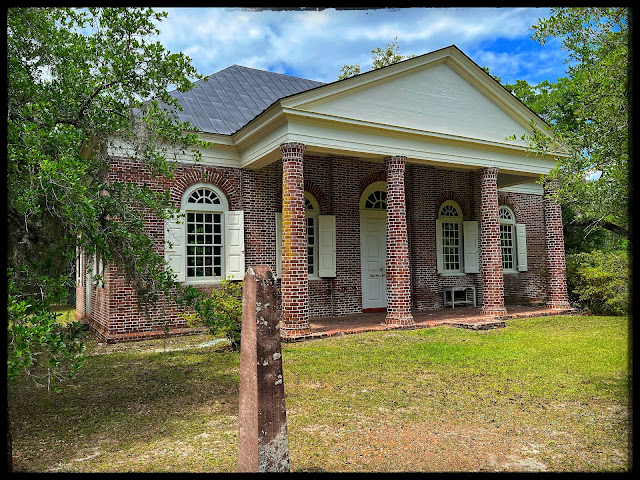
Posts

Showing posts with the label #travelswithkelli

Colonial Dorchester

Image
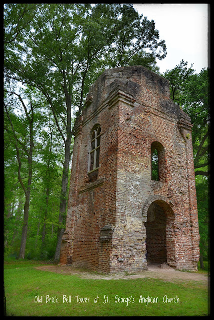
DESTINATION AWAITS:  Today I ventured up on the Ashley River to colonial Dorchester. This is located on the Ashley River and was a thriving town until the start of war when it all but disappeared. Today we enjoyed the “exploring life in Colonial Dorchester.” Talked to several reinactors from a field doctor to soldiers. ADDRESS:  300 State Park Road, Summerville, SC JUST THE FACTS (BRIEF HISTORY): *Concrete fort made of oyster-shell that was broken down and turned into lye to create the concrete. Broken shells were also added to the concrete mix. *Church build in 1719, tower added 1751 *15 miles up stream from Charleston *Ashley River was its main route for transportation of goods. *1675 John & Mary Smith came from England and was granted 1800 acres. But after his death his land went back to the state. *Mary went on to marry Arthur Middletown then Ralph Izard. These are two important families of SC *1696 a settlement of Massachusetts came down to “settle the gospel” *Bell T...

McClellanville, SC

Image
DESTINATION AWAITS:  McClellanville is just off route 17 approximately halfway between Charleston and Georgetown. It seems I have been taken by this quaint town. See the posts listed below. This small fishing village originated in the late 1860’s. It was land owned by AJ McClellan and RT Morrison. At some point they sold lots near the Jeremy Creek to planters. The town started to blossom with the first store opening after the civil war. The village turned from producing timber, rice, cotton to the seafood industry around 1926. This town is still known for its shrimping, yearly they have a Lowcountry Shrimp Festival and Blessing of the Fleet. The festival occurs the first Saturday of May each year.  One fact I found quite fascinating, 1989 the eye wall of Hurricane Hugo passed over the village destroying various homes, boats, and other things. The villagers took up refuge in the local high school. The storm surge went so high that they had to get to the crawl space above the fa...

Hampton Plantation

Image
          DESTINATION AWAITS: Today's adventure brought me to Hampton Plantation in McClellanville, SC off Old Georgetown road AKA kings highway). This sits on the on the Wambaw Creek which is a branch of the South Santee River.  Here are the points of interest for this plantation.  ADDRESS: 1950 Rutledge Road, McClellanville, SC JUST THE FACTS (BRIEF HISTORY): * Location: 1950 Rutledge Road, just off US 17 and not far from the Old brick Church. Read about the church here . *MAKE SURE YOU BRING BUG SPRAY. The mosquitos are so bad.  * Several sources give the plantation a few different names: Horry Plantation or now known as Hampton but its main crop was rice. *Established 1735 by Daniel Horry and has been owned by his descendants until sold to the SC parks service in 1971 when Archibald Rutledge died. * House was built in the Georgian style and later wings on the two sides were added.  *To keep it even there are windows on the second floor t...

SeeWee Restaurant

Image
  Location: 4808 N Hwy 17, Awendaw, SC Driven by this place numerus times and every time it has a parking lot full of cars. Today I got a change to eat there, and I will be going back. I love the feel of the place.  Here's a little about the place. Seewee comes from an Indian Tribe from the Awendaw area. The building was originally used as a general store in the early 1920's. It has changed owners and in 1993 it was converted to a restaurant. A lot of the decor is reminiscent from that time. I like the old time feel of the place. It reminded me of T. W. Graham restaurant in McClellenville. Like Graham it is a neighborhood staple. They have great southern home cooking and use local ingredients which helps out the community.  (who doesn't love that.) I understand there is a patio and live music is often played.  Our waitress said that the she-crab soup was the best. My favorite so far has been 82Queen in Charleston. This one is just as good and this one there are defin...

Lowcountry Shrimp Festival

Image
 Today we came for the Lowcountry Shrimp Festival. This small festival did not disappoint. It was so much better than the blue crab festival.  This quaint town has its own village museum. This little museum is worth the visit. Mr. Hill the proprietor was there the day we went and he was knowledge about and gave a tour of the museum .    This year was the 45th festival. It all started in 1977 (and if you do the math that doesn't add up - there was a 2 yr. hiatus). The event starts with the blessing of the shrimp fleet. This area is loaded with shrimp boats. These boats float down Jeremy Creek getting blessed before the upcoming shrimp season. This happens towards the end of the festival.  Location: McClellanville, SC. Just off route 17 Parking: across from festival $10 per car, but if you don't mind walking you can park on the street. Just make sure you are off the road so cars can get by. Activities: Blessing of the fleet, live music, various craft venders with ...

St James Santee Parish Church

Image
DESTINATION AWAITS: Today's adventure took me on a dirt road to a beautiful church.  Located on a very well maintained dirt church known as St James Santee Episcopal Church but originally was known as the Wambow church for it was located near the creek and plantation of the same name. (FYI there is also one in McClellanville). In 1706 the Province of Carolina  charter of the Church of England parish was established. They divided which is now South Carolina into 6 parishes. This parish was the first one outside the city of Charles Towne and extended from the Awendaw Creek to the Santee River. The church was built in 1768. It was built in the single-story brick and slate hip roof Masonry structure. The church was built on King's Highway which later was named Old Georgetowne road.   JUST THE FACTS (BRIEF HISTORY): * Area around the church and Santee River was rice plantations * Brick was imported from England * Columns constructed by local wedge shaped bricks made by sl...

Charlestowne Landing

Image
  DESTINATION AWAITS:  Today’s historic adventure was to the first colony of South Carolina, that was established in 1670. Not the oldest colony in the new world. That award goes to St. Augustine in 1565.  This English colony was built on the marshy point just off the Ashley River. It consists of 664 acres and includes a Animal forest (aka zoo), an African American cemetery, the Legare Waring House, Founders Hall, and excavation that’s on going.  Sadly I was not able to see the house or the hall due to private events. Guess that means a return trip and another blog dedicated to them.  Below are a rendition of what the housing would probably been like back then. There was places to show how they farmed. It was interesting to hear that they thought that sugar cane and tobacco would have been successful. After trial and error they found peas, rice, indigo to name a few.  Over all my thoughts : * turning into the drive you are transported to another place. The ...

Beacon of the lighthouse

Image
DESTINATION AWAITS:  Sullivan’s Island Lighthouse is now part of the NPS. The lighthouse itself  isn’t open to visitors, but during the day you can roam the grounds. I thought I did a blog about it but can’t find it so here we go again.  ADDRESS: 1815 ION ave, Sullivan's Island, SC JUST THE FACTS (BRIEF HISTORY): * It’s know also as the Charleston Light * Most modern lighthouse in the country * Triangular and slim in structure, this design while halo withstanding hurricane force winds up to 125 mph * White color blocks before changing to Black blocks (the black replacing the orange coloring) * height 140 ‘ foot tall, staying same with until it reaches the beacon light fixture * original light fixture was a 28 million candle power optical (quickly replaced) *  construction began in 1960 completed in 1962  * This modern lighthouse has both an elevator and AC  * in 2008 ownership changed from Coastguard to the NPS though Coastguard still check & maintains ...